Perspective of Banking, Financial Services & Insurance

Although the banking industry in India has seen many positive developments in the last decade, one of the key concerns is financial exclusion of a large proportion of the population. As such the challenges of this industry are:

  • Increase the penetration of banking in India to address the demand supply gap: With number of banks per 1000 population still being abysmally low, banks have a need to increase their penetration to improve financial inclusion of our people
  • Credit disbursement to the priority sector: A key challenge of the banking system is to provide the priority sectors especially the agriculture and Small scale industries timely and cost effective credit which as a result is very important in generating employment and supporting the growth of the economy
  • Maintain asset quality: The advances of banks that are unsecured have increased substantially. To remain profitable banks need to keep the quality of their assets high
  • Improve risk management mechanism: Banks need to setup specific risk management procedures to make the business more viable. One of the key requirements that Banks need is reliable data access for far-sighted risk management
  • ATM revolutionized....to take ATM's at the doorstep where there is population and area is secured through Geo-coding services and other solutions

MapmyIndia Offerings

MapmyIndia has advantage to provide End-to-End GIS Solutions across different platforms (Web, Mobile, WAP, and Desktop). MapmyIndia has unique build process for its map and map related datasets. In addition, MapmyIndia maps have extensive map coverage both in urban and rural India and most importantly MapmyIndia can provide integrated solutions as well.

MapmyIndia Geo-Coding Services for Customer Mapping

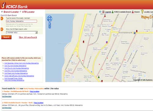
MapmyIndia can help get coordinates of an address (state, city/town/village, street, locality, sub-locality, landmark etc). For e.g. Marine Drive, Mumbai, OR Block S, Greater Kailash 2, New Delhi, OR Siwan, Bihar. MapmyIndia geo-coding algorithm is tuned to India's complex/unorganized address system and it intelligently provides relevant best and alternate matches.

Get Your GIS Data Acquired Easily from MapmyIndia

MapmyIndia provides various GIS data at National and City/Town Level GIS Data

  • 1. National Level GIS Data
  • 2. City/Town Level GIS Data

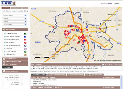
Get Authentic & Reliable Geo Tagged Market & Business Intelligence Data from MapmyIndia

MapmyIndia provides various data such as affluence data, thematic maps, population data, landmark/ POI data, hazard maps and market surveys to businesses and corporate to help them assess market potential, competition presence, and own distribution presence as well as business performance and compliance measures which can be visualized, analyzed and validated geographically on a map.

  • Affluence Data and thematic maps
    • Household Data (HH) in terms of
    • Population Data
  • Landmark/POI Data – 160 categories ranging from ATM's, Banks, restaurants, hotel, shopping markets etc
  • Hazard Maps- this will interest insurance companies where they can get full information about floods, earthquake data for risk profiling, while giving policies the companies can do risk assessment
    • Hazards analysis provides you with maps that indicate which areas in your community are most susceptible to hazards
    • Quantification of current and future risk for the exposed area (making a "risk profile")
  • Market surveys

Web Analytic Solutions

MapmyIndia provides web solutions which are planning and analysis centric and can be provided for mobile, web and WAP platform

  • 1. ATM/branch locator
  • 2. Pan India Mapping of All Bank's ATM and branches
  • 3. Interactive driving direction from user specified areas to bank locations
  • 4. Display of branch and ATM attributes as part of the location on the map
  • 5. Periodical updates of branches and ATMS of . Pan India Map coverage- which gets refreshed automatically
  • 6. The locator services will be integrated with bank's website

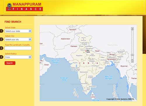
Get Your Mapping Done Easily from MapmyIndia

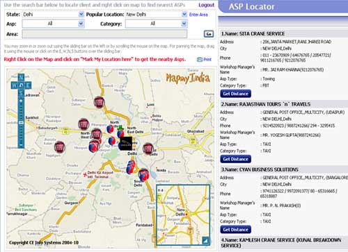
MapmyIndia provides policy mapping where you can locate your customers resources and Policies on a map for better analysis capability

  • 1.Use the nationwide town data/pin code to map locations anywhere in the country
  • 2.Map all of your policy holders, their policy limits, and other characteristics so that you can assess your risk exposure
  • 3.Systems takes the reference of risk location to map policies using base data
  • 4.Options to map policy data at town, pin code level

Insurance Underwriting-Mapping Services

  • Map locations that are prone to various risks or that have particular demographic characteristics
  • Identify areas on a map with a high population density, a large concentration of properties, or other demographic characteristics that effect whether to underwrite a property for fire or burglary insurance
  • Determine if a home is in a flood plain, near a fault, or is susceptible to wild fires and other hazards to make informed
  • decisions on whether to underwrite a property for hazard insurance
  • Find the driving distance or straight line distance to the nearest fire station or police station