1 second can save a life – use the most efficient Emergency Response System.
If for example, a fire occurs, any delay of responding fire department can make the difference between the rescue of occupants versus serious injury or death. The critical time between fire containment and flashover can be measured in seconds. Similarly, in the case of medicial emergencies, ambulance dispatch, route and pick-up/drop-off of the patient is crucial to try and ensure positive outcomes. Fast access to critical information is essential. Tools that help emergency response personnel (like firefighters or paramedics) pinpoint the emergency call location, assess the potential consequences, determine shortest route to reach there, strategize to minimize property damage and protect the occupants is the need of the hour.
Mechanism required:
- Incident Management and Response System
- Automated Building Plan Approval Systems (for Fire)
System Components
MapmyIndia provides comprehensive utility services catering specific requirements of various clients by USP of
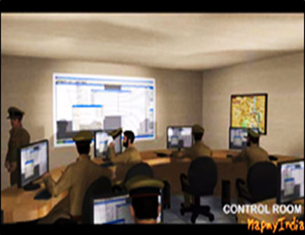
The ICCS plays a vital role in the incident management activation. It coordinates the flow of information with respect to activities associated with relief operations. During a crisis it is expected to function as a center for decision making and to keep constant touch with the affected areas to provide organized relief and rescue operations immediately after occurrence or receipt of warning of disaster.
ICCS will be equipped with systems capable of archiving all the information related to the incidents reported on regular basis. Apart from information of incidents, ICCS has modern IT infrastructure to manage communications, visualization of incident locations, videos and actual movements of the fire vehicles on a large video wall.
MapmyIndia provides comprehensive utility services catering specific requirements of various clients by USP of
- Data Centre / Server Room/Rack for ICCS
- Operation Centre with Operator Workstations
- Video Wall
- Electrical Backup System
- Debriefing(/re-construction) Room at Central Control Room
Disaster Recovery is replica of the ICCS to support any kind of disaster which may cause damages to the control center to the extent of non-operations. DR site is maintained away from the main site and equipped with all the systems available in the main control center.
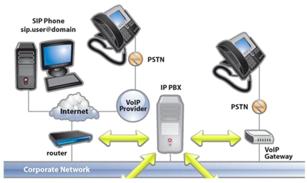
Communication is main enabler of the Dial – 101 system. All the calls landing on 101 will be routed through an automatic call routing system to the next available call taker.
System consists of an IP PBX server, SIP phones and VOIP Gateway to connect to existing PSTN lines. The IP PBX server, systems functions in a similar manner to a proxy server: SIP clients, being both soft phones or hardware-based phones, register with the server, and when they wish to make a call they ask the server to establish the connection. The server has a directory of all phones/users and their corresponding SIP address and thus is able to connect an internal call or route an external call via either a VOIP gateway or a VOIP service provider.
Components of Communication System
- VoiceXchange – IVRS: This is a configurable call flow generator, It offers a fully integrated Interactive Voice Response (IVR) product to connect your customers, databases, telephones
- Automatic Call Distribution Module (ACD): This forms a part of the voice Xchange an Intelligent Call routing mechanism is achieved using ACD Module. Calls are transferred to the agent based on certain logic such as equal distribution of calls, Skill based routing, etc.
- Computer Telephony Integration Module (CTI): Using the CTI module, the system integrates with the CRM and Populates the information on the screen of the agent
- Central management Software: Creation of extensions, Trunk, Channel setting, CDR management.
- Voice Recorder: Voice recorder records the conversation of the agent and call.
AVTS is another key component of the fire incident management and response system. In the typical implementation of the system, all the fire vehicles are fitted with GPS Devices to transmit the current position of the vehicles. In the recent days, GPS devices are replaced by multi-purpose Mobile Data Terminals (MDTs), which can work as navigation, video streaming and also transmit latest positon of the vehicle.
- AVTS, an integrated part of ICCS & GIS will provide GPS navigation facility for each fire emergency vehicles.
- AVTS will track each fire emergency vehicle’s position with the help of Mobile Data Terminal (MDT)/GPS Device installed in respective vehicles.
- The MDT installed in the fire emergency vehicles will help rescue team with turn by turn navigation for respective City, house number search, points of interest (Fire Stations, Hospitals, Blood Banks, etc) etc.
- Comprehensive routing/vehicle movement technology – will allow users to locate their vehicle anywhere, Should be capable of data mining – archive data and obtain vehicle movement history, capable of geo-fence locations on the go etc.
- AVTS server communicates with MDT through GPRS/GSM technology.
- MDT will be using Global Positioning System (GPS) for keeping the track of position/location
CAD system is one of the critical components of the fire incident management and response system. The CAD software system has three modules for taking calls, dispatch and supervisor.
All the three modules are synchronized to work in cohesive fashion to manage any reported incident.
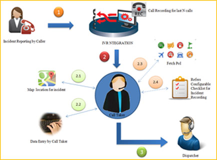
Call Taker Module
Call taker is responsible for logging the incidents reported by the caller. All the calls landing the communication system will be routed to the call taker enter full details of the incident reported.
- Incident Reporting by dialing 101 which will land on communication setup of the Dial 101 system
- Communication system has find the call taker, who is free to receive the call and routes the call
- Call taker identifies the location on GIS map with the help of the description and address given by the caller
- Call taker logs the call details
- Looks for the nearest landmarks to describe the location better
- Call will be closed by the call taker by referring the checklist as per the SoP
- Call will be logged in the system queue for dispatcher to pick it up
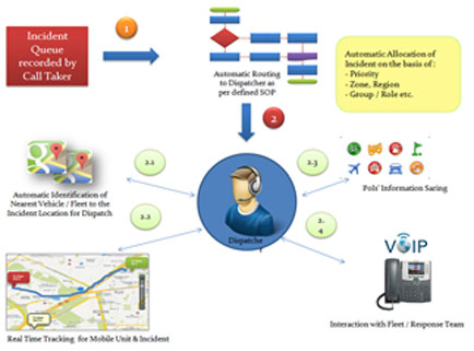
Dispatcher Module
Dispatcher module takes care of dispatching the resources (fire vehicles) to the location of incident. Dispatcher will make decisions to dispatch vehicles based on the description provided while logging incident by call taker.
- Dispatcher module automatically identifies the incident location and adds the incident to the queue of respective zone, region and priority)
- Dispatcher picks up the next available incident for dispatch
- Module provides with options of nearest available resources by automatic identification based on live position of the resources (fire vehicles)
- Dispatcher picks up the resources from the options based on the incident location and type of fire
- Share location details on the MDT and shortest route to reach the location
- Also calls the response team over the VoIP call
Supervisor Module
Supervisor has additional powers to dispatch additional resource as per the assessment done. Supervisor can also get more details on incident location by searching through information within the data archives. Supervisor will have access to internal video walkthrough of the buildings and structural designs, which will be sent to MDTs for the assistance in rescue operations.
Advanced map & data is major archive of the data in the control room. The data is mainly divided into 2 parts GIS maps and walkthrough videos of all the major buildings (buildings having height greater than 100 MT).
GIS Data
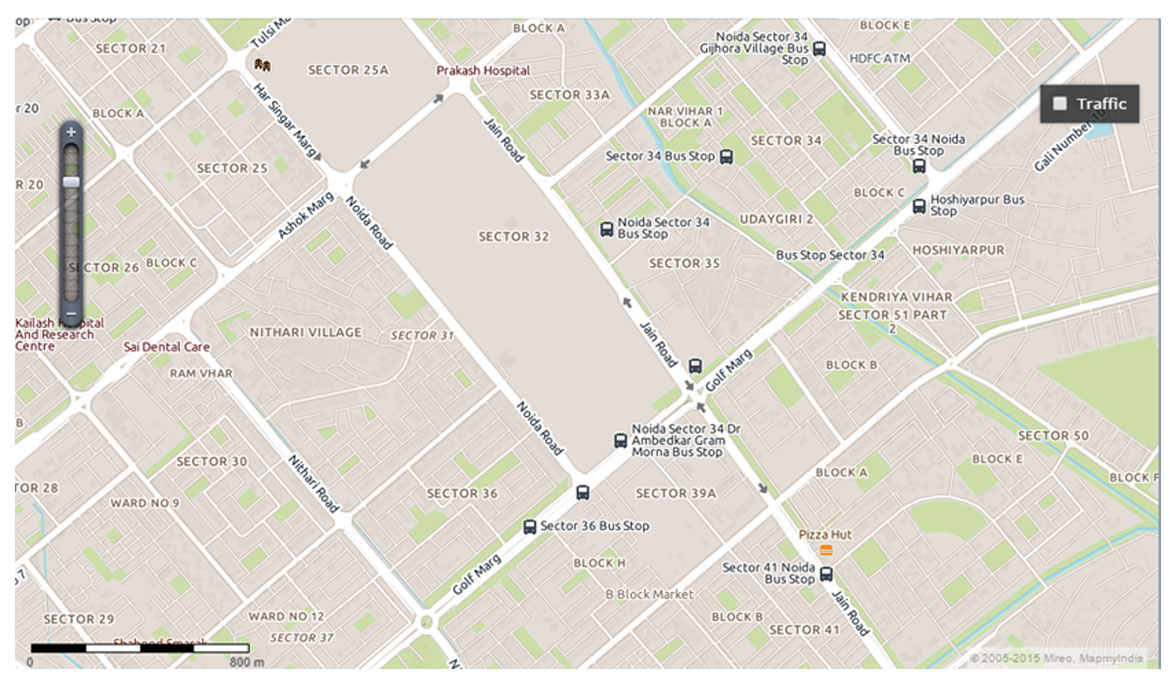
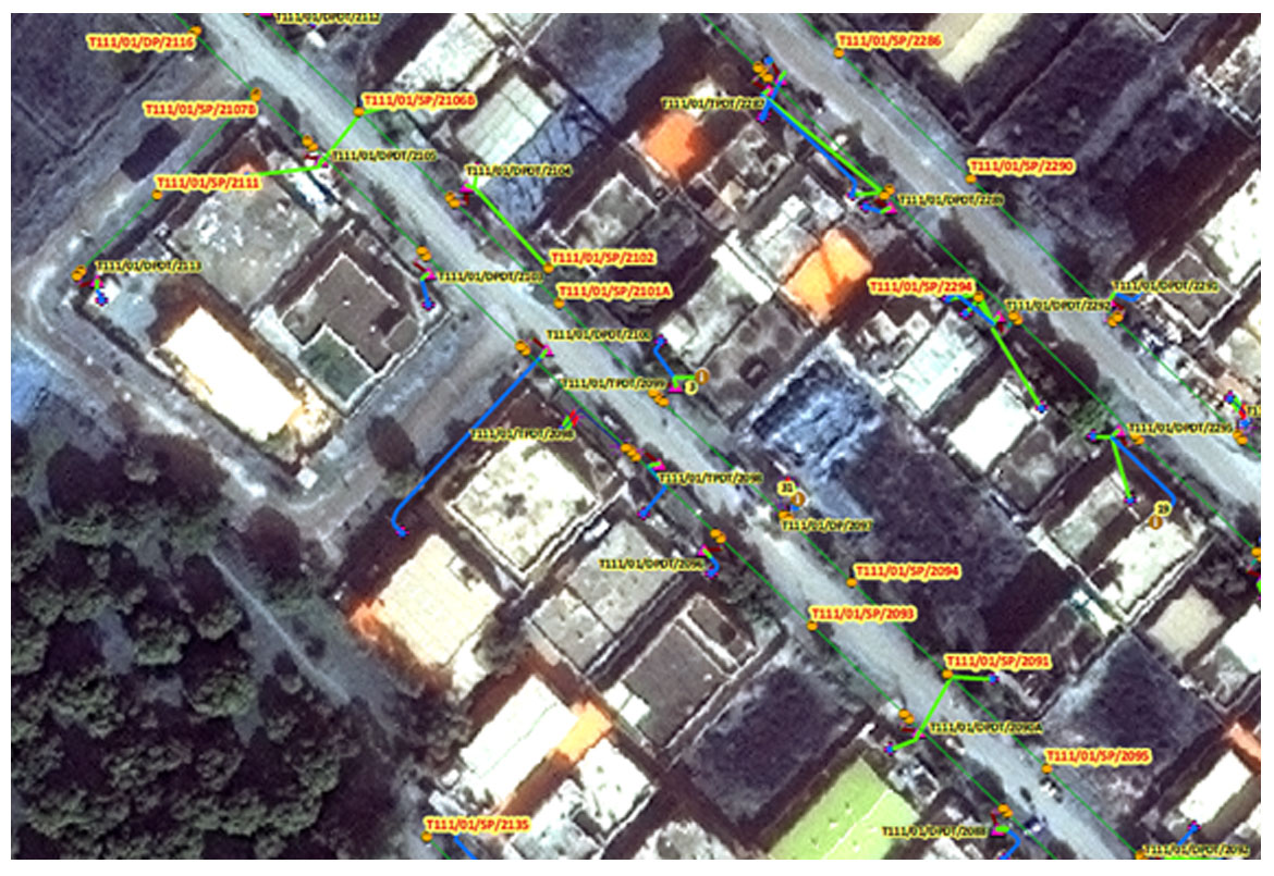
The function of the GIS is to provide the digital mapping interface for the display and query. It also serves as one of the display engines for vehicle's location and status information collected from the Automatic Vehicle Tracking System (AVTS) servers located at Central Control Room. GIS Map of City (1:1000) with all the main buildings, roads, traffic junctions and other point of Interests will be made available as part of the overall systems.
Key aspects of the GIS data include
- Road network will be segmented in a manner that it has unique junction nodes and can supports routing algorithm to navigate and calculate distance to each individual locations
- Roads will be classified properly on the basis of usage, average speed, road conditions, connectivity etc. so that priority of each road segment is properly set
- Road network shall be segmented at Every intersection of two or more roads, Every administrative boundary level, Where rail track intersects with any road objects, Every road segment having a corresponding start and end junction longitude and latitude to create the whole routable road network. Further every segment shall be attributed with a unique identifier; name, if it exists and its length
- Road network continuity shall be maintained to enable navigation/routing.
- Administrative layers shall represent parent-child relationship. For example, each record in locality layer shall have a parent defined as city name. This shall apply to all administrative layers
Disaster Recovery is replica of the ICCS to support any kind of disaster which may cause damages to the control center to the extent of non-operations. DR site is maintained away from the main site and equipped with all the systems available in the main control center.
The Power of Location for Emergency Response
Hear from Government Visionaries & MapmyIndia Experts
Sample Screenshot


Request Call Back
There's so much that Mappls MapmyIndia can do for your enterprise or individual requirements. Explore our website to learn more or request a callback/email if you'd like us to connect with you.
or