-
Products
Products
- Map and Data
Map and Data
-
![]() Map
Data
Map
Data
Location data reflecting the real world
![]() Geo-demographic
Data
Geo-demographic
Data
Updated, reliable, industry data
![]() RealView
RealView360° panoramic street images
![]() Map Portal
Map Portal
India’s original internet mapping portal
![]() eLoc
eLoc
Doorstep digital address system
![]() HD Maps
HD Maps High precision 4D maps
![]() Metaverse 4D Maps
Metaverse 4D Maps Immersive maps reflecting the real-world
-
- APIs and SDKs
APIs and SDKs
-
![]() See all APIs
See all APIs 
Explore our entire suite of APIs & SDKs
![]() Maps
Maps
SDKs for maps and traffic
![]() Search & Geocoding
Search & Geocoding
APIs for search and discovery
-
![]() Routes & Navigation
Routes & Navigation
APIs to solve complex routing problems
-
![]() Navigation SDK
Navigation SDK
Connected embedded navigation
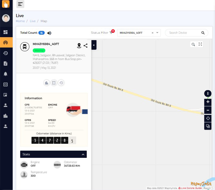
![]() Mobility & Tracking
Mobility & Tracking
SDK to enable live location in your apps
-
![]() Global APIs
Global APIs
Maps, search, routes for 238 nations
![]() Personalisation SDK
Personalisation SDK
Hyperlocal, personalised O2O marketing
-
![]() Optimisation APIs & SDKs
Optimisation APIs & SDKs
Route planning & optimisation
![]() GIS and Analytics APIs
GIS and Analytics APIs
GeoBI meets Location AI
![]() Workmate APIs
Workmate APIs
Field force automation APIs
![]() MapmyIndia Move URLs
MapmyIndia Move URLs
Embed maps, navigation in your apps
![]() NaviMaps SDK APIs
NaviMaps SDK APIs
Hybrid navgation for embedded systems
-
See all
APIs
![arrow]()
-
- GIS, Analytics and AI
- IoT and Automation
- Navigation and Mobility
Navigation and Mobility
![]() NCASE Automotive Suite
NCASE Automotive Suite
Intelligent mobility platform for PV, CV, EV
![]() Navimaps
Navimaps
Offline navigation maps and app
![]() Mappls App
Mappls App
Super app for maps, safety, and more
![]() Mappls Gadgets
Mappls Gadgets
GPS enabled IoT gadgets
-
![]() Navigation SDK
Navigation SDK
Connected embedded navigation
![]() Traffic AI (coming soon)
Traffic AI (coming soon)
Convert movement data to traffic analytics
- Drone Services
- Map and Data
- Solutions
- Consumer
- Developers
- Investors
-
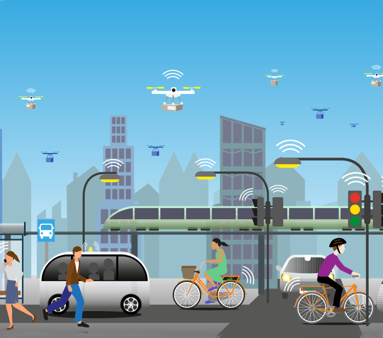
Transform Governance, Empower Citizens
Innovative indigenous geospatial products and solutions by MapmyIndia - fully aligned with India’s mission towards being Aatmanirbhar and Self-reliant.

-
MapmyIndia and ISRO collaborate to bring together the best of indigenous satellite & mapping technologies

-
Providing tax authorities with location insights related to tax coverage, payments and tax evasion

-
MoU with National Institute of Urban Affairs (NIUA)
35 crore Indians in 4000+ towns to benefit from the geospatial partnership

-
MoU with India Meteorological Department (IMD)
Supporting industries and common citizens with the latest weather information through geospatial solutions

MapmyIndia products and solutions are
trusted by
Government organisations at all
levels - Center, State and Local

Central Board of
Direct Taxes

The Reserve Bank
of India

Goods and Services
Tax Network

Maharashtra
Police

Telangana
Police

Indian Space
Research Organisation

National Institute of
Urban Affairs

Airports Authority
of India
India
Post

Silvassa Municipal
Corporation
Agartala
Smart City

MIDC Fire
Department

MP
UADD
Geospatial dashboards for strategic planning, efficient operations and effective management
Powered by India’s most comprehensive
and accurate maps
MapmyIndia Geospatial Solutions
-
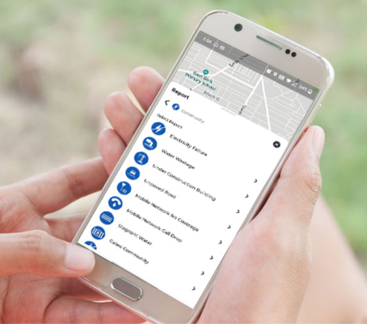
Citizen Connect
Citizen participation and inclusive governance
MapmyIndia brings administrators and citizens closer through the Citizen Connect solution.
- Citizen Connect app for citizens to share their grievances with location component
- Create awareness among citizens about administration led initiatives
- Helps administrators listen to the voice of the citizens, track issues geographically and earn goodwill by quick turnaround times for grievance response and resolution
-
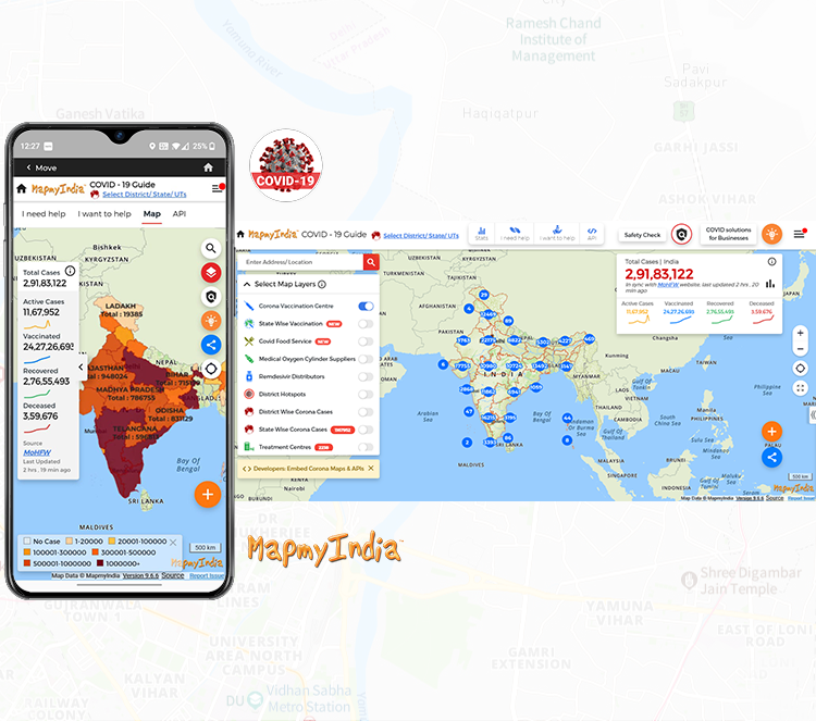
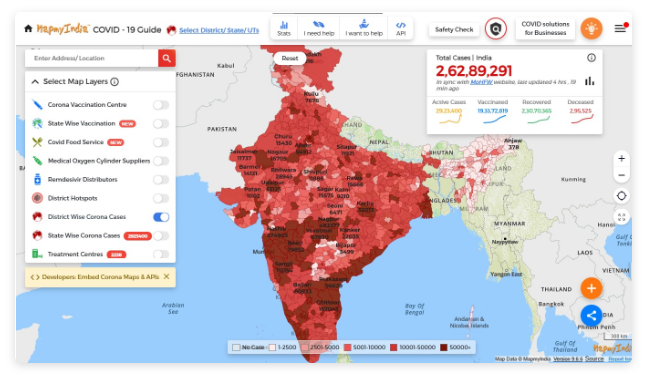
Community Health
Know the impact of health hazards and plan in advance
MapmyIndia GIS based situational awareness for medical emergencies/pandemic management.
- Spatially enabled dashboards to study the health risks and plan mitigation
- Identify affected people, communities on a map to define micro quarantine areas, helping break the chain
- Help the public find medical aid quickly, thus saving lives
-
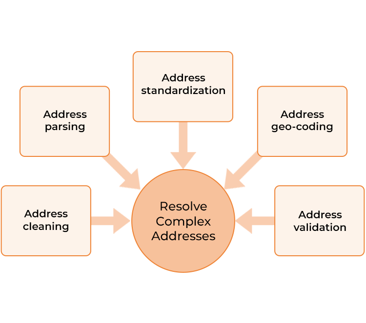
Address Quality
Tag location to the addresses for spatially analysing patterns
- Address is an extremely important piece of information for business and governance. Quality addresses help in better analysis and decision making.
- Our Address Standardization and Geocoding solution puts the address in a location perspective to generate highly desirable location insights
- Solution built on the most comprehensive reference data dictionary developed in-house by compiling millions of address points
-
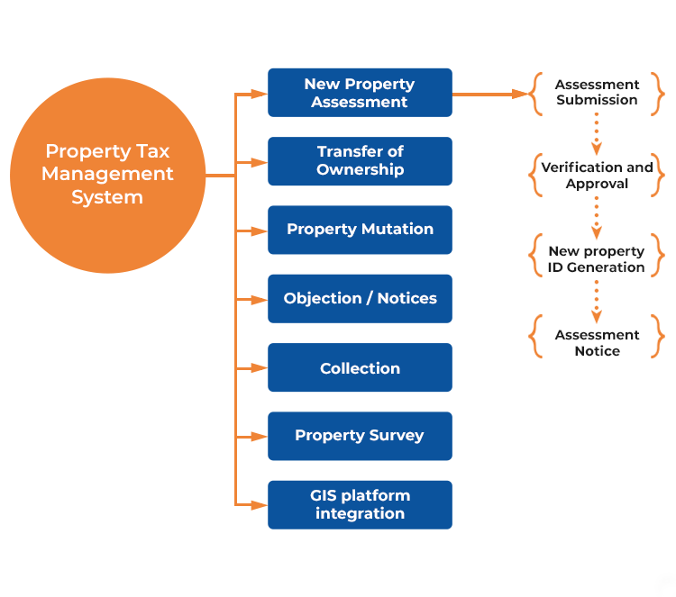
Property Tax
Enhance property tax coverage, demand and collection
Our solution provides business continuity to Urban Local Bodies (ULBs) through the most comprehensive software system.
- Configurable dashboard for Chief Officers/ Commissioners to know the overall status in one snapshot
- Helps in data collection, assessment, demand generation and tax collection
- Integrated with GIS system, solution has separate modules for internal stakeholders and common citizens
-
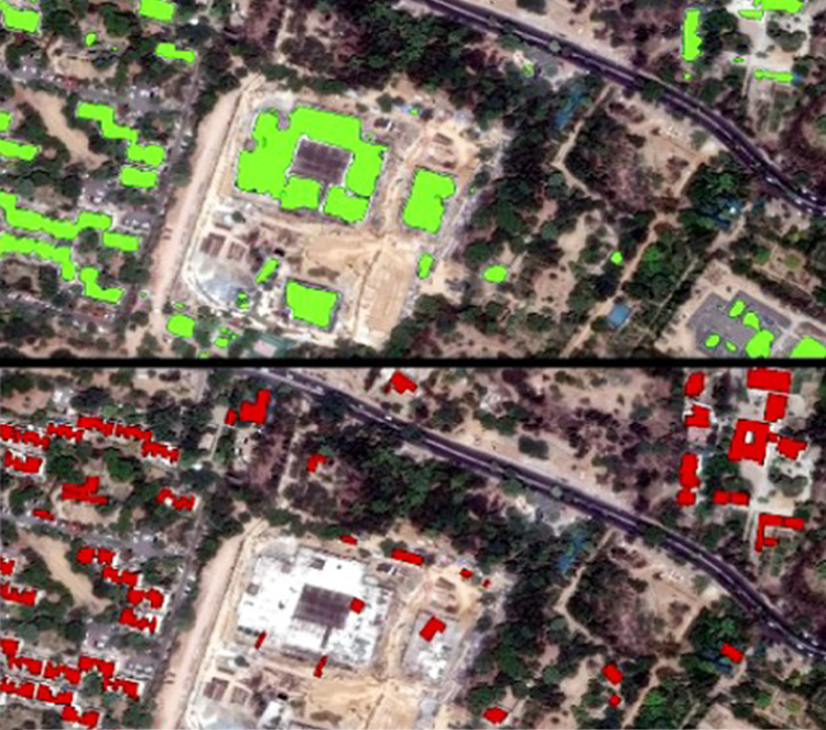
Change Detection
Change detection and decision support
With our Geospatial AI/ML-based solution for change detection, we help:
- Identify encroachments in large urban areas
- Identify crop patterns for helping farmers and insurance companies/banks to settle compensations faster
- Discover most affected areas during natural disasters for planning and operations
- Study eco-sensitive areas for deforestation to cease environmental hazards
- Study congestion at various traffic junctions through video change analytics
-
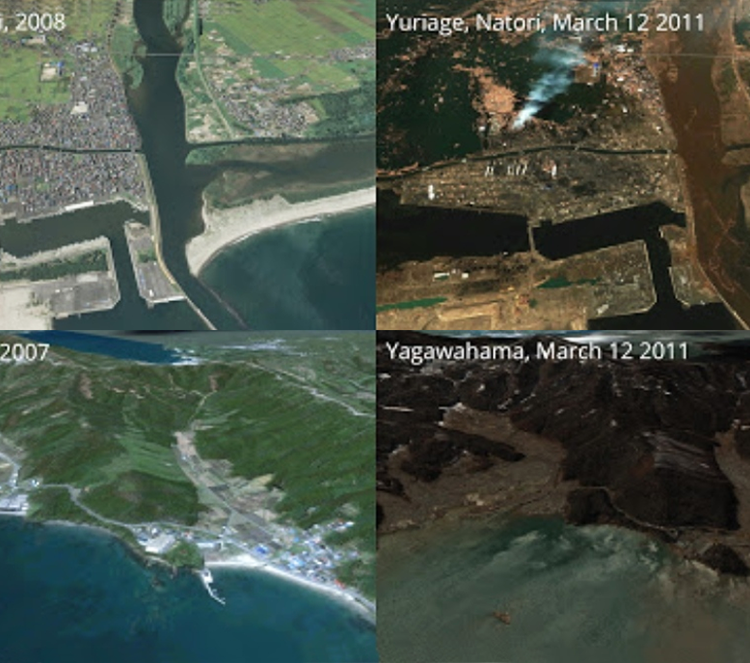
Disaster Planning
Strategies and preparedness plans
Preparedness for disaster reduces the impact by a large extent.
Our geospatial solution is a combination of detailed, accurate maps combined with high resolution satellite data for performing simulations to estimate the extent of losses and plan preparedness by identifying:
- Strategic locations for deployment of forces
- Routes for evacuation of people within time constraints
-
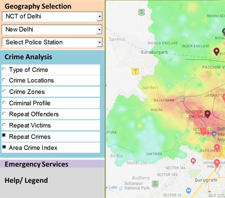
Crime Analytics
Geospatial analytics to prevent crimes
Crime data with location information can be effectively analysed to prevent future crimes.
Our solution helps agencies to:
- Create crime maps, geo-tag all the crime locations
- Combine historical data for identification of crime patterns with geospatial AI
- Predict possible criminals through locations, patterns and modus operandi of crime
Citizen participation and
inclusive governance
MapmyIndia brings administrators and citizens closer through the Citizen Connect solution.
- Citizen Connect app for citizens to share their grievances with location component
- Create awareness among citizens about administration led initiatives
- Helps administrators listen to the voice of the citizens, track issues geographically and earn goodwill by quick turnaround times for grievance response and resolution
Know the impact of health hazards and plan in advance
MapmyIndia GIS based situational awareness for medical emergencies/pandemic management.
- Spatially enabled dashboards to study the health risks and plan mitigation
- Identify affected people, communities on a map to define micro quarantine areas, helping break the chain
- Help the public find medical aid quickly, thus saving lives
Tag location to the addresses for spatially analysing patterns
- Address is an extremely important piece of information for business and governance. Quality addresses help in better analysis and decision making.
- Our Address Standardization and Geocoding solution puts the address in a location perspective to generate highly desirable location insights
- Solution built on the most comprehensive reference data dictionary developed in-house by compiling millions of address points
Enhance property tax coverage, demand and collection
Our solution provides business continuity to Urban Local Bodies (ULBs) through the most comprehensive software system.
- Configurable dashboard for Chief Officers/ Commissioners to know the overall status in one snapshot
- Helps in data collection, assessment, demand generation and tax collection
- Integrated with GIS system, solution has separate modules for internal stakeholders and common citizens
Change detection and decision support
With our Geospatial AI/ML-based solution for change detection, we help:
- Identify encroachments in large urban areas
- Identify crop patterns for helping farmers and insurance companies/banks to settle compensations faster
- Discover most affected areas during natural disasters for planning and operations
- Study eco-sensitive areas for deforestation to cease environmental hazards
- Study congestion at various traffic junctions through video change analytics
Strategies and preparedness plans
Preparedness for disaster reduces the impact by a large extent.
Our geospatial solution is a combination of detailed, accurate maps combined with high resolution satellite data for performing simulations to estimate the extent of losses and plan preparedness by identifying:
- Strategic locations for deployment of forces
- Routes for evacuation of people within time constraints
Geospatial analytics to prevent crimes
Crime data with location information can be effectively analysed to prevent future crimes.
Our solution helps agencies to:
- Create crime maps, geo-tag all the crime locations
- Combine historical data for identification of crime patterns with geospatial AI
- Predict possible criminals through locations, patterns and modus operandi of crime
MapmyIndia IoT Solutions
-

Emergency Response System
Quick turnaround time to reduce damages
Our solutions for emergency response provide various benefits:
- Quicker reporting through citizen connect
- Identification of emergency locations through comprehensive AI-based search engines
- Identification of nearest PCR/rescue teams with IoT devices
- Optimise time to reach the location through precise routing engine
- Multi-lingual voice guidance on NaviMaps to reach locations
-
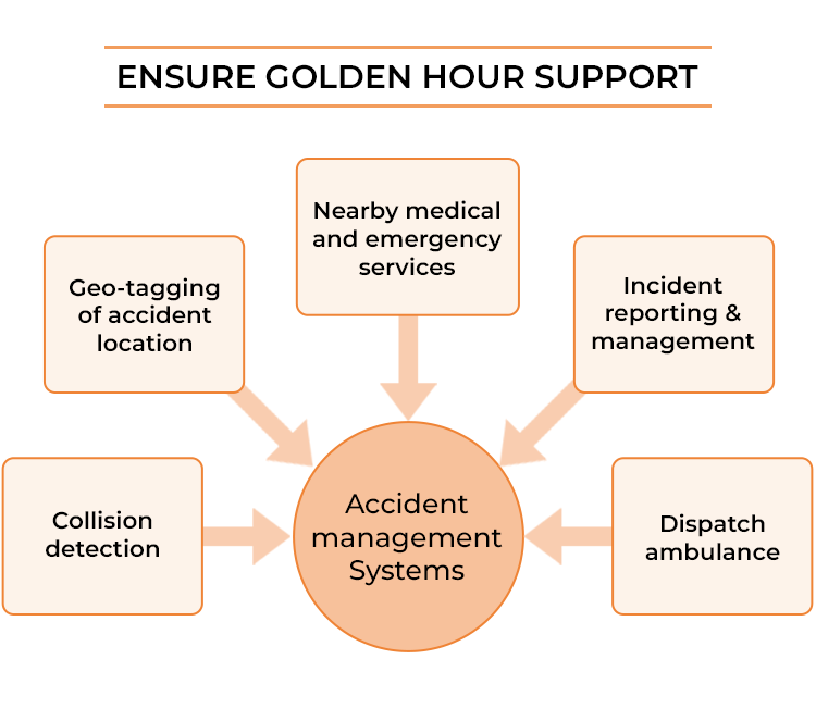
Accident Management System
Minimise accidents, impact and time for treatment
With an average of over 4.5 lakh accidents and 1.5 lakh fatalities, road safety is a serious concern in India.
- Minimise accidents: Alerting drivers in advance about dark spots and accident prone areas through navigational aids
- Minimise impacts: Identify locations (dark spots) on highways/roads having no access to medical facilities
- Treatment: Identify accident spots, help emergency teams to find the nearest ambulance and hospital to ensure treatment in the golden hour
-
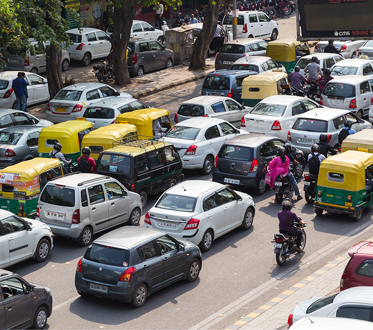
Intelligent Traffic Management
Minimise travel time, encourage green driving and ensure road safety
Our solutions for smart traffic management include:
- Identification of congestion points with live traffic information combined with historical traffic profiles and AI/ML-based algorithms
- Simulating and planning new infrastructure alternatives
- Automatic traffic light management with stoppage times in each direction based on current traffic queue length
- Real-time video analytics to promote safe driving by keeping a check on overspeeding, lane driving, direction of travel or other traffic violations
-
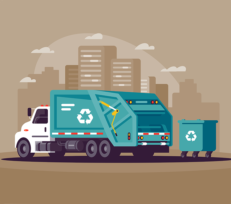
Solid Waste Management
Optimise SWM operations
Our solution optimises the processes through an end-to-end ICT based operations management and monitoring system with:
- Route planning based on high-resolution, house-level MapmyIndia Maps
- Door-to-door waste collection powered by MapmyIndia IoT devices
- Live monitoring of operations through InTouch Platform
- Analytics to improve efficiency and optimisation of costs
- Public grievance management through citizen connect
-
Smart Street Lighting
Reduce energy consumption with citizen satisfaction
- Street lighting is a need of community service and 18% – 38% of our power resources are consumed in fulfilling this need.
- Our streetlight management solution is an IoT-based solution that helps optimise power consumption to save cost of services.
- Solution includes CCMS panel, an IoT device connected to street lights with individual light controls to program the system for automated operations, movement based switching and recording of power consumption data for performing analysis to optimise costs
-
Asset Monitoring
Keep track of critical assets
Our IoT-based solution supported by precise location intelligence offers wide variety of features and functionalities to keep track of critical assets and asset misuse:
- Live monitoring of asset locations and alerts when moved out of their operational periphery
- Detect operational status of the asset through IoT-based sensors
- Optimum utilisation of assets by analysing historical data of their usage
-
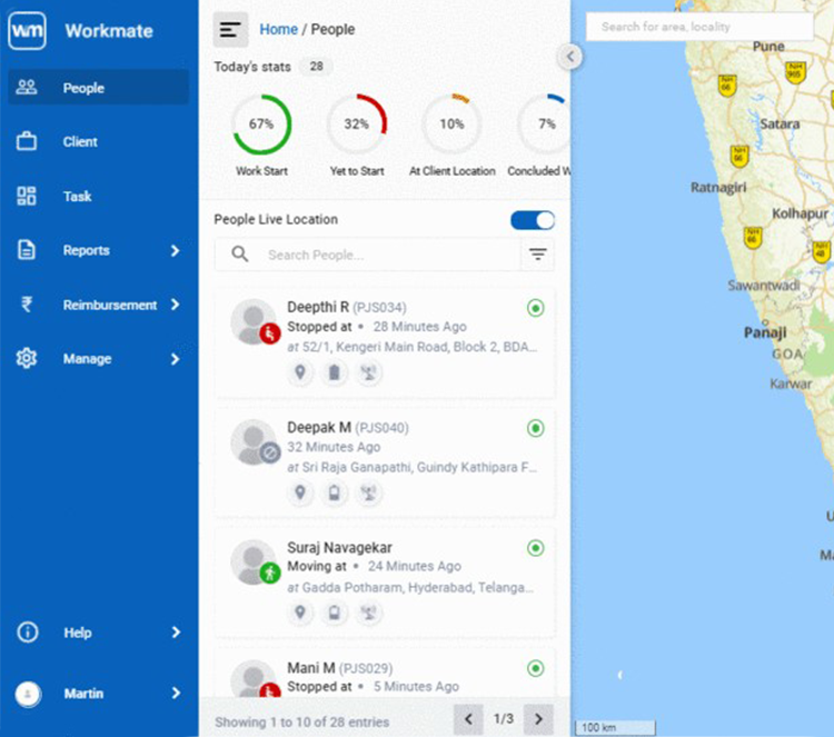
Field Force Management
Improve operational efficiency of field force
Our solution for field force management provides features to optimally manage field teams with live monitoring of resources.
- Remote attendance marking facility on the app through biometric systems
- Optimise travel routes based on service window and locations
- Supervisors can assign locations of duties to field resources and monitor their activities through notifications/alerts
- Analyse data for performance measurement of field resources
Quick turnaround time to
reduce damages
Our solutions for emergency response provide various benefits:
- Quicker reporting through citizen connect
- Identification of emergency locations through comprehensive AI-based search engines
- Identification of nearest PCR/rescue teams with IoT devices
- Optimise time to reach the location through precise routing engine
- Multi-lingual voice guidance on NaviMaps to reach locations
Minimise accidents, impact
and time for treatment
With an average of over 4.5 lakh accidents and 1.5 lakh fatalities, road safety is a serious concern in India.
- Minimise accidents: Alerting drivers in advance about dark spots and accident prone areas through navigational aids
- Minimise impacts: Identify locations (dark spots) on highways/roads having no access to medical facilities
- Treatment: Identify accident spots, help emergency teams to find the nearest ambulance and hospital to ensure treatment in the golden hour
Minimize travel time, > encourage green driving and ensure road safety
Our solutions for smart traffic management include:
- Identification of congestion points with live traffic information combined with historical traffic profiles and AI/ML-based algorithms
- Simulating and planning new infrastructure alternatives
- Automatic traffic light management with stoppage times in each direction based on current traffic queue length
- Real-time video analytics to promote safe driving by keeping a check on overspeeding, lane driving, direction of travel or other traffic violations
Optimize SWM Operations
Our solution optimises the processes through an end-to-end ICT based operations management and monitoring system with:
- Route planning based on high-resolution, house-level MapmyIndia Maps
- Door-to-door waste collection powered by MapmyIndia IoT devices
- Live monitoring of operations through InTouch Platform
- Analytics to improve efficiency and optimisation of costs
- Public grievance management through citizen connect
Reduce energy consumption with citizen satisfaction
- Street lighting is a need of community service and 18% – 38% of our power resources are consumed in fulfilling this need
- Our streetlight management solution is an IoT-based solution that helps optimise power consumption to save cost of services
- Solution includes CCMS panel, an IoT device connected to street lights with individual light controls to program the system for automated operations, movement based switching and recording of power consumption data for performing analysis to optimise costs
Keep track of critical assets
Our IoT-based solution supported by precise location intelligence offers wide variety of features and functionalities to keep track of critical assets and asset misuse:
- Live monitoring of asset locations and alerts when moved out of their operational periphery
- Detect operational status of the asset through IoT-based sensors
- Optimum utilisation of assets by analysing historical data of their usage
Improve operational efficiency of field force
Our solution for field force management provides features to optimally manage field teams with live monitoring of resources.
- Remote attendance marking facility on the app through biometric systems
- Optimise travel routes based on service window and locations
- Supervisors can assign locations of duties to field resources and monitor their activities through notifications/alerts
- Analyse data for performance measurement of field resources
Verticals
Products
mGIS
AI/ML based GIS engine to explore, upload, analyse, visualise your data geo-spatially
InTouch Platform
Monitor your assets, vehicles and people using InTouch - a scalable and reliable IoT platform
Hardware & Sensors
India’s widest range of reliable and OTA (Over-The-Air) configurable IoT devices
Insight
Configure your own dashboards with maps, graphs, charts
 Mapmyindia
 Government ministries, institutions and local authorities trust MapmyIndia
-


Fantastic example of home grown cutting edge technology. MapmyIndia has built detailed map products for all of India - GIS maps, 3D maps, real view, indoor etc. MapmyIndia provides a comprehensive tech stack, and has rich national & international map data. Built in India for India and the world.
Shri Amitabh Kant CEO, NITI Aayog
-

E-filing of returns has built a fairly robust database of taxpayers - when we combine the income tax return with other information we get from third party reporting (banks, deductors, property registrars) we are able to find relevant information for ensuring compliance. This means every person should pay the right amount of tax. So, in that process, we are leveraging MapmyIndia's geocoding and GIS capabilities to be more effective in data utilisation.
Shri Sanjeev Singh ADG, CBDT
-


I appreciate MapmyIndia's support in helping the nation combat COVID by offering free GPS tracking systems and tech support to medical transport vehicles for smooth, quick, and uninterrupted movement of oxygen, vaccine, hospital beds and other essential medical infrastructure.
Shri Saurabh Gaur Joint Secretary, MeitY
-


MapmyIndia mapping technologies combined with other components will help in many governance issues, the safety of commuters, mapping resources of government and future development planning of a city. The use of maps by the government departments will help save and earn a lot more for the state revenue departments and make administration simpler and easier.
Shri K. Makrand Pandurang (IAS) Director General, Department of Town & Country Planning, Govt of Haryana


There's so much that Mappls MapmyIndia can do for your enterprise or individual requirements. Explore our website to learn more or request a callback/email if you'd like us to connect with you.