- Products
Products
- Mapping APIs & SDKs

 Maps
Maps
SDKs for maps and traffic

 Personalisation SDK
Hyperlocal, personalised O2O marketing

 Search & Geocoding
APIs for search and discovery
-

 Routes & Navigation
APIs to solve complex routing problems
-
![]() Optimisation APIs & SDKs
Optimisation APIs & SDKs
Route planning & optimisation
-

 Navigation SDK
Connected embedded navigation

 RealView APIs (coming soon)
APIs for 360° panoramic images
- Analytics APIs
- Telematics APIs & SDKs
- MapmyIndia apps APIs & SDKs
- Advanced APIs & SDKs
- Maps
SDKs for maps and traffic
- Personalisation SDK
Hyperlocal, personalised O2O marketing
- Search &
Geocoding
APIs for search and discovery
- Routes & Navigation
APIs to solve complex routing problems
-
Navigation SDK
Connected embedded navigation
-
![]() Optimisation APIs & SDKs
Optimisation APIs & SDKs
Route planning & optimisation
- RealView APIs (coming soon)
APIs for 360° panoramic images
- Mapping APIs & SDKs
- Use Cases
- Documentation
- Demos
- Custom Solutions
- Customer Stories
The names you trust, trust MapmyIndia.
Serving industry leaders across big tech, corporates,
automotive
and government authorities.
Experience the most relevant and accurate search results for any place, address or a pair of geo-coordinates with the industry’s best Search products.
We offer a wide range of solutions to cater to search requirements related to place discovery with the help of our powerful Autosuggest and Nearby Places Search solutions.
Our Geocoding solution is powered by MapmyIndia’s vast address database that can geocode any urban or rural address. Get human-readable addresses associated with geo-coordinates with the help of our Reverse Geocode.
With our Place along the Route, you’ll never feel new to any location while driving.
Benefits

Real Time Map Updates
MapmyIndia’s versatile team of data moderators continuously enhances search databases as per changes in the real world and ensures the completeness of the information.

Auto Scaled Services
MapmyIndia Search APIs can serve the needs of large clients with auto scalable services that provide consistent performance at any scale and with pre-informed, negligible maintenance downtime.

Advanced Search Features
MapmyIndia has around 300+ POI categories with 1500+ phrases/keywords search support, resulting in extremely user-friendly and easy-to-use search experiences to end users.

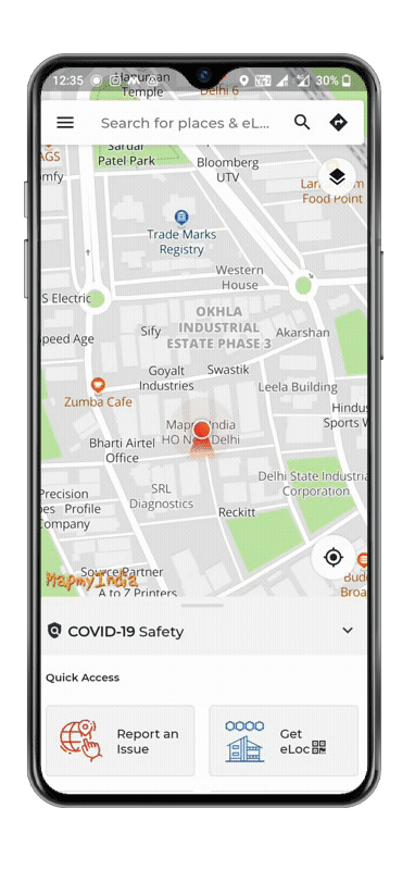
eLoc
MapmyIndia Search APIs are powered with a unique and revolutionary addressing system, eLoc - a unique 6-character digital address that provides the exact location to the doorstep of any place.
Search Solutions

Autosuggest Search
‘Type-As-You-Go’. Get the best places suggestions as per user input strings before the user completes the desired place name. Learn more

Nearby Search
Enables you to add discovery and search for the nearby places using unique category codes and generic keywords. Learn more

Text Search
Quickly finds all the best instances of search results for places name, address, keywords, etc. Learn more

Geocode Search
Converts any readable address into highly accurate geographical coordinates, be it for any POI, house number, area, pincode, etc. Learn more

Reverse Geocode
Get the closest real, human-readable address to a provided set of geographical coordinates, along with nearest landmarks on the map Learn more

Address Standardization
Enables the user to parse incomplete or unformatted single line addresses to get the complete and standardised address output. Learn more

POI Along the Route
Add convenience to the user by providing nearby places of desired categories along the set route. Learn more

Place Details
Returns the most updated and detailed information of a place with its eLoc. Learn more

Custom Location Search Services
Custom Location Search Services are SaaS based services in which any third-party customer can push and manage their own custom dataset and easily make it searchable. Learn more

Geolocation Solution
Returns a location and accuracy radius on the basis of cell tower information that any mobile client can detect. (coming soon) Learn more
Autosuggest
Autosuggest API helps users complete queries faster by adding intelligent search capabilities to your web or mobile app
- Smart Search Suggestion MapmyIndia Autosuggest API offers Smart Search functionality in which it gives smart keyword suggestions as per the user’s input string.
- Indic Feature Enables the user to input text in Hindi language and also get the results in Hindi language.
- HyperLocal Search Enables consumer tech apps and enterprises to give the address/place suggestion around a user’s location.
- Area Type Based Search Results Serve the use cases where any application is required to give a smart drop-down list of areas or sub-areas e.g. cities, localities, villages etc.
- Real Time Updates in Search MapmyIndia’s data moderators regularly update and add new places according to the changes in the real world.
- Area Bound Based Search Results Serves the use cases where any user or application wants to return the search results within a specific area e.g. state, city, locality, etc.
Nearby Places
Nearby Places API enable users to search nearby POIs by searching
for
generic keywords used to describe a category of places
or via
the unique code assigned to that category
- Custom Dataset Support Any user can enable their custom dataset in Nearby API with a dedicated assigned custom category code using MapmyIndia’s 3rd party dataset enabling capabilities.
- Indic Feature Enables the user to input text in Hindi language and also get the results in Hindi language.
- Real Time Updates in Search MapmyIndia’s data moderators regularly update and add new places according to the changes in the real world.
- HyperLocal Search Supports the additional hyperlocal place categories as per the need of real world changes e.g. hyperlocal information on COVID like Covid centres, vaccination centres, etc.
- Nearby Search Filters Powerful functionality to apply dynamic filters on various attributes as per category. Serves the common use case of EV charging station discovery where the user wants to search charging stations according to the vehicle’s compatibility and other preferences.
- Configurable Radial Search Additional functionality to override the limits of radial search.
Text Search
Text Search API provides information about a list of places
on the basis of a text string entered by the user
Quickly find all the best instances of search results on the input string. This API enables the user to get the search results for places name, keywords, formatted and unformatted addresses.
- Indic Feature MapmyIndia Text Search API has an Indic feature which enables the user to input text in Hindi language and get the Indic results.
- Real Time Updates in Search Powered with the Hyperlocal Place Search feature. MapmyIndia data moderators regularly update and add new places according to the changes in the real world.
Geocoding
The Geocoding API converts any real address into highly
accurate real-world geographical coordinates i.e.
coordinates
- High Precision Geocoding Returns the best results using MapmyIndia’s own comprehensive address directory which is a unified data product representing Indian addresses at different levels of granularity, be it POI, house number, landmark, street, area etc.
- Geocode Quality Indicators Provides quality indicators like geocode level with confidence score to get conviction on the provided coordinates.
- Area Bound Based Geocoding Supports the feature to restrict the geocode within any area or sub-area boundary like pincode, city, subdistrict, district or state.
- Area Type Based Geocoding Enables to limit the geocode results to any area type. For example, if any user wants to restrict the geocode at street level, house level, POI level etc.
- Single as well as Multiple Results Supports single results as well as multiple results based on requirement.
Address Standardization
MapmyIndia’s Address Standardisation API is an integrated
service
enabling a complete flow of address cleansing, normalisation,
validation and standardization for an input address .
This API is trained on MapmyIndia’s comprehensive address directory which is a unified data product representing Indian addresses at different levels of granularity. Supports modular functions to utilise the workflow as per business needs.
- Address Cleansing Removal of unwanted special characters, improper spaces, name duplications and other undesired strings present in the address string.
- Address Validation & Normalization Enables identifying the component parts of an address and parsing it into individual tokens and returns normalised results. Additionally, it validates the address components and determines the resolution level.
- Standardization Returns the address matched against MapmyIndia’s address directory for standardising address tokens and validating the administrative chain of an address. This process also populates missing values at the time of validating the administrative chain.
Reverse Geocode
Reverse Geocoding is a process to give the closest matching
address to a provided geographical coordinate
(latitude/longitude).
MapmyIndia Reverse Geocode API provides real addresses along with nearest landmarks for any such geo-positions on the map.
- Indic Feature MapmyIndia Reverse Geocode API has an Indic feature which enables the user to input text in Hindi language and get the Indic results.
POI Along the Route
Gives the details of nearby places of desired categories along the set route
The main focus of this API is to provide convenience to the user and help him/her in locating the place of his/her interest that falls on the set route while on navigation.
- Long Route Support Supports the computation of place results for long routes.
- Optimized Services Scaled and highly optimised services that give consistent performance on navigation.
- Accurate Data Results Returns the most accurate and updated place information along the route.
- Within Your Reach Added functionality to change the nearby radial search limits.
Place Details
Place Details API returns detailed information of a place related
to place
type, address, contact details, operating hours,
etc. MapmyIndia Places’ dataset has a wide
range of place
attributes for different types of place categories.
Every place is assigned with a unique digital address, eLoc. Only this eLoc can be used to extract the details of a place.
- Third Party Dataset With MapmyIndia’s 3rd party dataset enabling capabilities, we can enable provider specific attributes in our Place Details API.
- Electric Charging Station Serves the most accurate and reliable detailed information on electric charging stations like machine type, plug type, slots, amenities, etc.
- Category Specific Rich Attributes Place categories are supported with a wide range of attribute sets. E.g. for restaurants - cost for two, cuisine, etc. and for hospitals - number of beds, specialisation, etc.
- Serve As Per Demand Able to serve the use cases where different information is required for different applications and services using static, dynamic, UI content-based information.
Custom Location Search Services
With MapmyIndia Custom Location Search Services, an organization
can directly
upload its dataset in personalized format and
integrate the MapmyIndia Custom Location Search API
in application
directly to enable search capabilities around the uploaded
dataset. User can perform
nearby custom data search along
with autosuggest and full text search capabilities.
- Easy to Implement Custom Location Search Servicess are available as SaaS APIs, hence removes the need for any organizations to collaborate or share their dataset to MapmyIndia to make it available in the MapmyIndia API services.
- Search Anything Anywhere Custom Location Search Services Get API enables any user to search the dataset around his reference location.
- Scalable usage Cloud services offer high scalability, which gives customers the option to access more or fewer services or features on demand.
- Self-Data Updates Rather than sharing the dataset with the MapmyIndia for data updates, customers can directly manage their dataset using POST, PUT and DELETE APIs.
- Accessibility and persistence Since these services are served from cloud map hence can easily be delivered with any applications over the internet.
- Customization These APIs follow open data structure. Hence, the data can be stored with any set of attributes. The APIs support customizable schema formats and can be integrated with other business applications.
- Controlled Access and Security Since these are cloud based service hence and the dataset in the secured AWS environment which are accessible to the authorized users only.
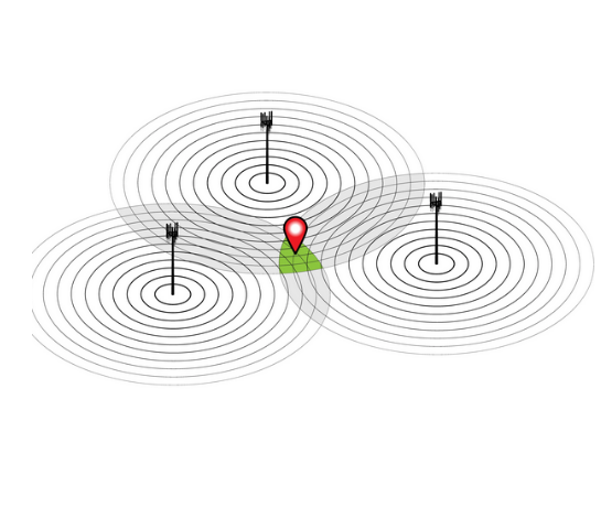
Geolocation
The Geolocation API returns a location and accuracy
radius
on the basis of cell tower information that
any mobile
client can detect.
Mobiles send the information of all the connected or recently connected cell towers. Once this is received, the API computes the user’s approximate location based on the provided cell towers’ information.
MapmyIndia uses its cell towers’ geo location database to calculate the approximate geo location of the user.
- Coming Soon...


There's so much that Mappls MapmyIndia can do for your enterprise or individual requirements. Explore our website to learn more or request a callback/email if you'd like us to connect with you.