Perspective of Travel & Tourism
It will come as a surprise to many to learn that in India the Tourism industry is one of the largest job creating industry and accounts for 5.9% of GDP, making it the highest contributor second only to oil and gas industry.
The thriving tourism industry faces umpteen challenges; the prominent ones being infrastructure, growth in skill, promotion and marketing at global levels, imparting of education related to Tourism, or improving the expertise in service management, etc. Further, tourism creates employment, development of far-flung regions, and maintenance of indigenous talent and gives a boost to local enterprise.
To address all of the above challenges, one of the major needs of tourism is to have accurate and up-to-date information in geospatial platforms on related entities so that different maps, GIS data, and applications can be generated for the tourism industry.
In addition to the above, promoting Tourism is the way to showcase the potential of our unique country to prospective traveller. Print and visual media are particularly important when it comes to promoting tourism opportunities anywhere. We are all aware of the old adage, a picture is worth a thousand words, and quite a few travel agencies, resorts, government campaigns are taking advantage of media such as print, Internet and television to tempt potential vacationers to travel to these destinations.
MapmyIndia Offerings
Best-In-Class Print Maps Based In GIS Data Repository
For the tourism Industry, MapmyIndia provides Print Maps which are based on its vast GIS enabled all India data repository. MapmyIndia's solutions for Travel and Tourism are made up of its series of National, State, & City map books and single-sheet maps that not only are a road atlas for these areas but also showcase the tourist attractions by showing them on the map pages, through their detailed pictures, drawings and descriptions, and include tools for trip planning, tips, cultural background etc. Whether cuisine, culture, climate, people, tourist places or 101 things, the book is a perfect amalgamation of information which will be the ultimate guide and planning tool for traveller to delve into the essence of the city, state, or country and these very definitely help in promotion and marketing of tourist destinations at domestic and international levels.
Customized Print Solutions
Be it displaying their dealerships on wall maps, showcasing their retail outlets and their vicinities, large city wide events' main venues, transportation companies' vehicle routes, MapmyIndia's customized map solutions is able to provide all this to customer's wall & brochure/booklet displays, satisfaction, and advantage.
Web & Mobile Mapping Using MapmyIndia GIS Dataset
Web Mapping (www.maps.mapmyindia.com) MapmyIndia has provided interactive web maps on the internet as a service to general consumers at www.mapmyindia.com. Tourists are able to go on this portal and get the directions from any source to any destination. Other than this, they are able to find nearest points of interest in a whole slew of categories such as restaurants, hotels, tourist places etc. All this helps a tourist in planning his travel, finding out places of interest in a place and also helps convert an internet portal visitor to a tourist thereby promoting tourism. These are free offerings. Mobile Mapping (m.mapmyindia.com)MapmyIndia has expanded its reach multiple-fold by providing its digital maps and data for mobile, using which you can not only navigate but do much more with the map such as find places, nearby places, save your favourite places, know the traffic situation or alert others about the incident. These are free offerings.
MapmyIndia Provides State-of-the-art Tracking & Navigation Solutions Tracking
MapmyIndia Tracking Solutions make a tourist's travel safe and secure. By choosing to travel in vehicles that have tracking, the tourists can ensure their itineraries are tracked and thus their near and dear ones can always know where they are.
MapmyIndia's tracking products and services for fleet or asset have been validated by a long list of customer acquisitions who have used the easy to use hardware product as well as well integrated software to successfully track their fleet or asset for the purposes of enhanced safely, security, cost-effectiveness, and streamlined operations
Navigation Solution
MapmyIndia Navigation solution comes power packed with features to make your life as easy and interactive as possible. Through Professional Guidance provided by the mobile navigation solutions, its Intuitive design, easy to read as you drive, crystal-clear spoken voice instructions and route guidance combines a fluid easy-to-use interface with MapmyIndia unmatched map coverage in India to make mobile navigation convenient and fun to use. The mobile maps come with MapmyIndia's comprehensive map coverage across India. Get street level directions in 4000 cities across India, search through a million points of interest; get information about roads as you drive down - and much more. Certain MapmyIndia solutions are your gateway to augmented reality providing for the first time in India 3d landmark & footprints in 34 cities. It allows you to search over 64 categories of points of interest and over 6.3 million unique destinations. It comes preloaded with city guide for 5 cities to keep you updated making a tourists visit fun & informative.
MapmyIndia Provides Unoque GEO Mobile Applications
MapmyIndia's mobile solutions for enterprises includes a host of different features & functionalities that can be made available across the Android, iphone & Blackberry platforms
MapmyIndia provides many services including locator services where a user can locate touch points such as stores, ministores, ATMs, etc. and view in on a map. Others are push services – these are push information to the user depending on his location. For example - offer locators for stores, restaurants, hotels, taxi services, push offers to users on the app developed by MapmyIndia depending on user's location, like if he steps into Shopper's Stop, he gets an alert about an offer in that outlet according to the location. Another service is photo integration service where MapmyIndia can also integrate and geo-tag pictures taken on the handheld device in the field. These pictures are sent back to a central server and integrated with the location data.
Examples of Travel & Tourism Solutions
Hop On Hop Off Tourist Bus
MapmyIndia partnered with HOHO Bus Service which was an initiative of Delhi Tourism and India's Largest Operator in tourism and inter- city bus services Prasanna Purple Tours Pvt. Ltd during the Common Wealth to cater to the inlet of tourism in Delhi. As part of this service, 14 air conditioned buses were launched in New Delhi, which were supposed to run on a fixed route having about 20 stops which were a mix of tourist attractions, shopping arcades etc. MapmyIndia provided their state of the art vehicle tracking system and GIS Platform to help operations and on time performance. The requirement of the project was to map the bus stops onto the digital map and geo fences were created for the same on the application. Further, the bus routes were studied and plotted on the map on which the vehicle data was overlaid. This helped the operations and management teams in keeping a check on route adherence.
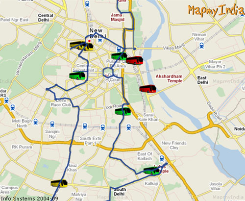
Map displaying tourist locations and bus-routes
Jammu & Kashmir Travel and map guide
MapmyIndia partnered with Jammu and Kashmir government in providing them with detailed travel and map guides which showed The J&K State Map Book provides an in-depth knowledge of the state in a strategically planned yet enthralling format. The book's inventive use of contextual facts, perceptive POI symbols, 3D images, colour coded geographical attributes, 101 Things to Do, variations on urban and rural regions offer a user-friendly approach for newbies' new found foray into map reading and an interesting read for the experienced. Covering an extensive spectrum ranging from history to cuisine, religion to recreation and nature to monuments, the book delves into the very essence of Jammu & Kashmir giving visitors the opportunity to be one with the rustic feel of the state. Its comprehensive coverage stretches from Kathua to Nubra Valley, including Jammu, Pir Panjal Range, Srinagar, Ladakh, Kargil, etc, in between.
Over 2300 POIs, detailed view of all primary areas, umpteen trekking routes, and connectivity of roads will keep the readers/visitors afresh to the 'Paradise on Earth' that is Jammu & Kashmir.
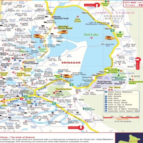
City map of Srinagar showing city map along with the tourist locations
Delhi NCR Mapbook
This is an initiative from MapmyIndia in aiding travellers and tourists of Delhi NCR. The book is the fastest and most interesting way to know and understand the area on the account of 3D images, contextual quick facts, colour coded land use, intuitive points of interest symbols, 101 things to do, 101 things to know, contextual economic information and comparison, highlighted planned residential neighbourhoods, with juxtaposed urban villages. The book provides map along with giving the key to overview and detail map pages, gives a traveller/tourist a perspective about how the city and its suburban areas are laid out in relation to each other, what are the key landmarks major stations, airports, most important arterial roads and expressways, interstate highway connectivity along with the major city they are connecting you to, and neighbouring states. Also, the book provides overview maps which gives user locality wise perspective of the city sprawl and allows navigation from one locality to another locality anywhere in the city. The detailed map pages help people in the last or first mile phase by showing them house numbers, building names, points of interest of more than 50 types.
The book offers coverage that includes entire Delhi urban sprawl and Delhi state, Gurgaon, Faridabad, Ghaziabad, Noida, and Greater Noida urban spread at the most detailed zoom level that has ever been available for this region to date.
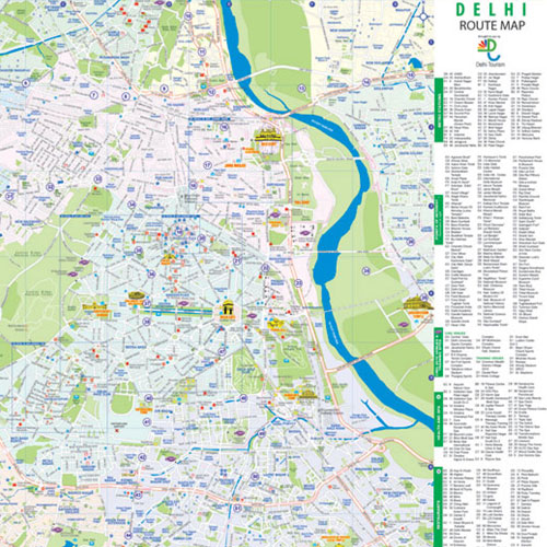
The sample of detailed route map for DELHI NCR mapbook
MapmyIndia Value Proposition
MapmyIndia has distinct and unique GIS offerings to Indian Government (central, state and local governments) – GIS services that no other Indian GIS company offers today in a combined manner. MapmyIndia aims to serve the needs of the government through focused, innovative, efficient and quality GIS products and GIS services of relevance to all areas of governance in central government, state governments and even local governments. MapmyIndia brings horizontal and vertical integration of satellite/aerial Remote Sensing, Ground Survey, Positioning, GIS databases and GIS applications, GIS web-services and overall system integration services in GIS. MapmyIndia has the best professionals and experienced technology advisers/consultants in this GIS technology and boasts of a top technical team. The MapmyIndia team, with its vast experience and expertise, provides the back-bone of innovative, quality and effective solutions to all sectors of governments, private sectors, academia and nongovernmental organisations.
Specific Government Programs
Since tourism was discovered as one of India's fastest growing markets which was creating millions of service industry jobs, Government of India also took the initiative of plugging the gaps. The Ministry of Tourism launched Incredible India campaign in 2002, promoting India as a premier vacation destination. The campaign was quite effective, making India one of the top destinations for travellers.

