With the advent of Geographical Information Systems, the existence of the computer was empowered with the collection and analysis of data with the spatial technology that is allowing us today; to understand, and interpret location enabled business intelligence. GIS didn’t just facilitate the creation of maps; it enabled the data behind them to be aggregated, analysed and explored.
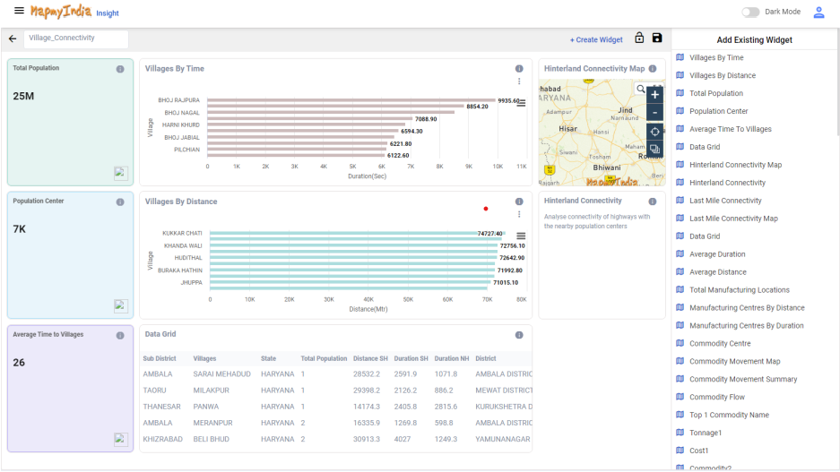
MapmyIndia Insight is Business Intelligence software that empowers you to add the spatial content to your existing reporting in any format for immediate Visual business analysis and location optimization. The web based software allows easy updation of structured information and is automatically synced with the geography. It helps to quickly visualize and analyze your records to extract previously hidden trends and insights based on location.
It is a powerful visual data generation tool that gives the power to add records or edit your uploaded records to the Mapmyindia’s existing spatial platform, straight from the Insight platform! It can sync location with other information components, such as pricing, sales data, competition data, outlet data etc. This user specific knowledge is imported from excel or csv file further geo-referencing it on MapmyIndia’s platform. The system is simple output data overlaying on maps and the result is visual spatial display of your output instead of tables and charts!! Giving insights to the purpose of your data captured. MapmyIndia maps are highly accurate and comprehensive: down to the house /street level data which help in automatic and precise geocoding of your information.
The tool provides customized filters to perform various geospatial analysis and planning : Potential/ Gap Analysis, Sales Analysis, site location analysis. It helps to add context and precision to businesses that can visually and precisely locate your customer, transactions or other data and thereby enriching it with a wide range of additional inputs such as demographics or risk for enhanced business insight.
The customized maps created are embedded in your website and can be seamlessly integrated to your business solutions. The information can be stored privately or shared with different user groups, colleagues, clients without sharing the raw data. The web system helps to share insights with other users to proliferate benefits through your organization.
Explore into the functionality behind easy-to-use web based mapping tool: Know more about the power of MapmyIndia Insights at www.mapmyindia.com/insight/. This is a self service mapping and analysis tool that combines an intuitive interface with powerful discovery features. It makes it easy for anyone to see and understand location data on Map.
The tool is utilized by banks, FMCG, Telecom, insurance, healthcare, retail and Healthcare to help solve their business problems, segment customer database, make sales & marketing effective, optimize distribution and supports various other business functions. Get free demo sign up here. Learn how to export your information on to the Mapmyindia’s spatial data and get the hands on experience of creating your own maps with your own set of values of qualitative or quantitative business variables.